Canadian Water Well Records: How to Access Alberta Water Well Records Online
If you are planning to drill a new water well in Alberta, researching existing Canadian Water Well Records is one of the most important first steps. By reviewing nearby well reports, property owners can better understand groundwater depth, expected water yield, drilling conditions, and possible construction requirements before investing in drilling services.
In addition, the Alberta government maintains one of the most comprehensive groundwater databases in Canada through the Alberta Water Well Information Database (AWWID). As a result, property owners, farmers, drilling contractors, and land developers can access valuable groundwater information to make more informed decisions about water well development. Furthermore, reviewing nearby records may help reduce drilling risks and improve project planning before drilling begins.
What Are Canadian Well Records?
Canadian Well Records contain technical and historical groundwater information collected from previously drilled wells. These reports may include:
- Well depth
- Water yield test results
- Geological formations
- Aquifer information
- Pump test data
- Groundwater chemistry
- Drilling reports
- Well abandonment details
Accessing this information before drilling can help reduce uncertainty and improve groundwater planning.
Alberta Water Well Records Search
The Alberta Water Wells Web Application allows users to search for groundwater information using:
- Legal land description
- GPS coordinates
- Owner name
- Well ID number
Knowing your legal land description or GPS coordinates is very helpful when searching the database, although searches can also be completed using the owner name or well identification number.
You can access the Alberta Water Wells database here:
http://groundwater.alberta.ca/WaterWells/d/
Additional information is available through the Alberta Water Well Information Database:
http://esrd.alberta.ca/water/reports-data/alberta-water-well-information-database/
Why Reviewing Existing Well Data Matters Our Electro Seismology Service is Covered
Researching nearby wells before drilling can help identify:
- Typical groundwater depths in the area
- Expected production rates
- Rock and soil conditions
- Areas with lower groundwater potential
- Historical drilling success nearby
This information may help property owners make better drilling decisions and avoid unnecessary costs.
Because some mapped locations are generated from legal land descriptions rather than exact GPS coordinates, users should review several nearby reports to gain a better understanding of local groundwater conditions.
Setback Requirements for Water Wells in Alberta
Before constructing a new well, property owners should understand setback requirements related to:
- Buildings
- Septic systems
- Sewage fields
- Property lines
- Potential contamination sources
Proper setbacks are important for protecting groundwater quality and meeting provincial guidelines.
For setback requirements from buildings and septic fields, please see:
http://environment.gov.ab.ca/info/library/8069.pdf
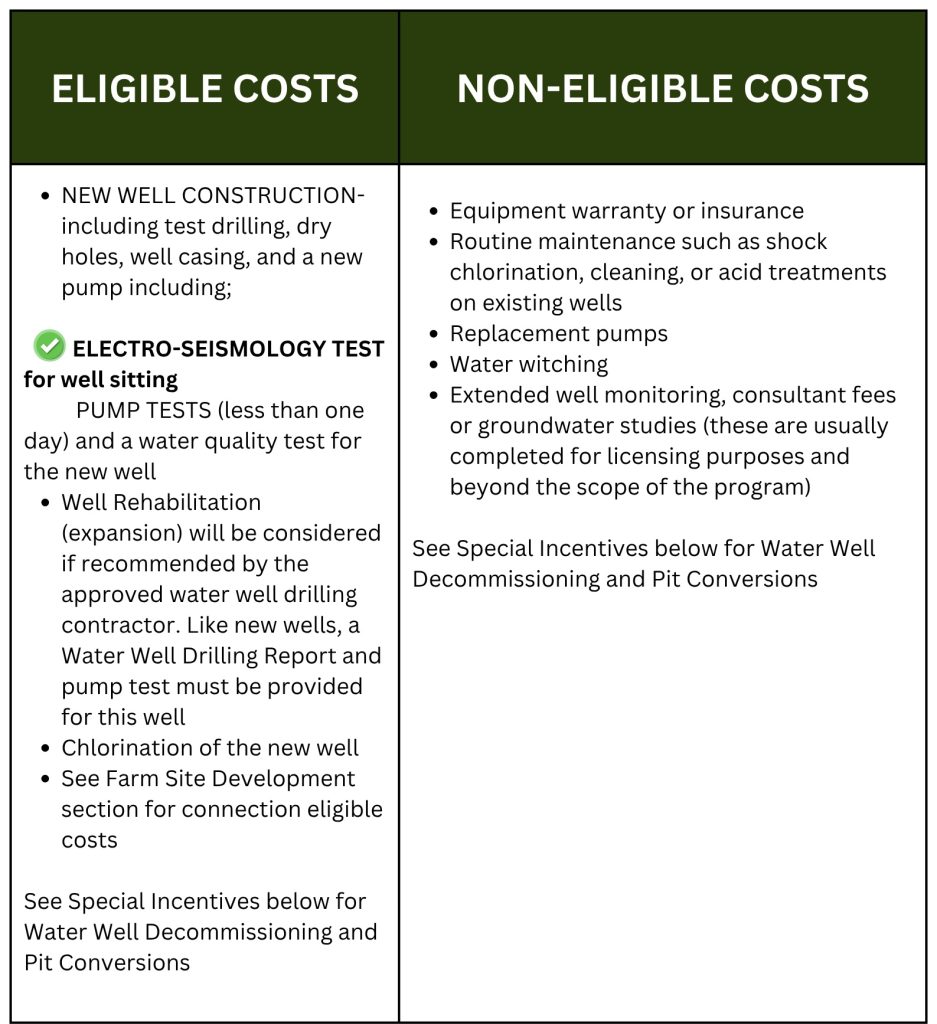
Funding and Grants for Farmers Drilling Wells
Farmers and agricultural property owners in Alberta may qualify for water management funding programs that assist with groundwater development and well drilling costs.
Some programs may help cover:
- Water well drilling
- Groundwater investigations
- Agricultural water supply improvements
- Water management projects
Funding and grant information for farmers drilling wells can be found here:
In some situations, approved groundwater investigation services may also qualify for funding support.
Tips for Researching Groundwater Information
When reviewing Alberta groundwater data, it is recommended to:
- Compare multiple nearby wells
- Review water yield and depth information carefully
- Examine geological formations encountered during drilling
- Use GPS coordinates whenever possible
- Consult qualified groundwater professionals before drilling
Groundwater conditions can vary significantly, even between neighboring properties, so existing records should be used as guidance rather than guarantees.
Canadian Well Records by Province
British Columbia Water Well Records
The British Columbia Ministry of Environment maintains an online groundwater well and aquifer database that allows users to search for water well information throughout the province. As a result, property owners, farmers, drilling contractors, and developers can quickly access important groundwater data before starting a drilling project.
British Columbia Water Well Database
http://maps.gov.bc.ca/ess/hm/wrbc/
In addition, the Ministry provides the eWELLS application for entering new well records into the database. Therefore, well information can continue to be updated and expanded across the province.
eWELLS Application
https://a100.gov.bc.ca/ext/ewells
Users can search for groundwater records using:
- PID number
- Land description
- Well tag number
- Property information
British Columbia Well Search
https://a100.gov.bc.ca/pub/wells/public/indexreports.jsp
Furthermore, additional groundwater and aquifer information is available through FrontCounter BC.
FrontCounter BC
http://www.frontcounterbc.gov.bc.ca/
Phone: 877-855-3222
Setback Requirements in British Columbia
Before drilling a new well, property owners should also review setback requirements related to buildings, septic systems, and contamination sources. Consequently, understanding these regulations may help protect groundwater quality and avoid future issues.
For setback requirements in British Columbia, visit:
http://www.env.gov.bc.ca/wsd/plan_protect_sustain/groundwater/library/faq_grdwater.html
New Brunswick Water Well Records
New Brunswick also provides online access to groundwater well information through its provincial database. Therefore, users can review local groundwater data before developing a new water source.
New Brunswick Water Well Database
http://app.elg-egl.gnb.ca/0375-0001/
Setback Requirements in New Brunswick
In addition, property owners should review setback regulations for buildings and septic systems before drilling.
Manitoba Water Well Records
At this time, Manitoba does not currently maintain a public online water well database. However, local government offices may still provide limited groundwater information upon request.
Newfoundland and Labrador Water Well Records
Groundwater and water resource mapping information is available through the provincial mapping system. Consequently, users can review regional groundwater resources and aquifer information online.
Newfoundland and Labrador Water Maps
Groundwater Information
http://www.env.gov.nl.ca/env/waterres/cycle/groundwater/index.html
Nova Scotia Water Well Records
Nova Scotia provides public access to well logs and groundwater information online. As a result, landowners can review nearby well data before drilling a new well.
Nova Scotia Well Logs Database
https://www.novascotia.ca/nse/welldatabase/wellsearch.asp
Saskatchewan Water Well Records
Saskatchewan provides groundwater and well management resources for landowners and rural property owners. Additionally, the province offers guidance related to groundwater protection and water well management.
Saskatchewan Setback Requirements and Well Management Guide
Ontario Water Well Records
Ontario maintains an online map and searchable database for water well records across the province. Therefore, property owners can research nearby wells and groundwater conditions more efficiently.
Ontario Water Well Records Map
http://www.ontario.ca/environment-and-energy/map-well-records
Yukon Water Well Records
Yukon groundwater and observation well information can be found through the Yukon Water database and federal aquifer mapping systems. In addition, users may contact Yukon Water Resources directly for specific well information.
Yukon Observation Wells
http://yukonwater.ca/monitoring-yukon-water/water-data-catalogue
National Groundwater Aquifer Map
http://ngwd-bdnes.cits.nrcan.gc.ca/service/api_ngwds:gin/en/wmc/aquifermap.html
For specific water well records, contact:
Yukon Domestic Water Well Program (Financing)
Furthermore, Yukon also offers information about domestic water well financing programs.
http://www.community.gov.yk.ca/property/domesticwaterwell.html
Legal Land Description (LSD) Converter
Many provincial databases require legal land descriptions for accurate searches. Therefore, the following tool may help convert legal land descriptions and related property information more easily.
LSD Converter
http://www.legallandconverter.com/
CONTACT US NOW!
+1 780 876 6676
3811-53 Ave Rocky Mountain House, Alberta T4T 1V4 Canada
If you would like to use our services, please email us and we will provide a DocuSign agreement along with a customized estimate. Waterfind is based in Rocky Mountain House, Alberta, and we travel almost anywhere in Canada to assist clients with groundwater location services.