How to Read a Water Well Record
A water well record is one of the most valuable documents a property owner can have. It contains detailed information about how a well was drilled, the geological formations encountered, the well depth, water levels, and the amount of water the well can produce. Understanding a water well record can help you evaluate your groundwater supply and make informed decisions about maintenance or future upgrades.
Key Information Found on a Water Well Record
Well Location
The record identifies the exact location of the well on the property, making it easier to locate for inspections, repairs, or future development.
Total Well Depth
This section shows how deep the well was drilled. Well depth varies depending on local geology and the depth required to reach a productive aquifer.
Casing Details
The casing is the protective pipe installed inside the well. The record typically lists the casing diameter, material, and depth, helping determine how the well was constructed.
Static Water Level
The static water level indicates the depth to water when the well is not being pumped. This measurement provides insight into groundwater availability.
Geological Log
A geological log records the soil, clay, sand, gravel, and rock formations encountered during drilling. It helps identify the water-bearing zones supplying the well.
Water Yield
Water yield is usually measured in gallons per minute (GPM) and indicates how much water the well can produce under normal conditions.
Water Well Yield Explained: Understanding Your Well’s Water Production
Understanding water well yield is essential when evaluating a groundwater supply for a home, farm, acreage, or commercial property. Simply put, water well yield refers to the amount of water a well can produce over a specific period. Because groundwater conditions vary by location, yield serves as one of the most important indicators of a well’s reliability and performance. A productive well can provide a dependable source of water for decades. Therefore, understanding how yield is measured can help property owners make informed decisions about their water systems. In addition, knowing a well’s production capacity can help prevent future water shortages.
What Is Water Well Yield?
In simple terms, water well yield describes the rate at which water can be pumped from a well while maintaining a sustainable supply. Most drilling professionals measure yield in gallons per minute (GPM) or liters per minute (LPM). Typically, groundwater enters the well through water-bearing formations known as aquifers. Consequently, the amount of water available depends on local geology, aquifer characteristics, and recharge rates. As a result, neighboring properties may experience different well yields even within the same region.
How Is Well Yield Measured?
Once drilling is complete, professionals often perform a yield test or pumping test. During this procedure, water is pumped continuously while technicians monitor water levels and recovery rates.
This testing process helps determine:
- Sustainable water production capacity
- Groundwater availability
- Appropriate pump sizing
- Long-term well performance
- Potential water supply limitations
Furthermore, yield testing provides valuable information about how a well may perform during periods of increased demand. Consequently, property owners can better plan for future water needs.
What Is Considered a Good Water Well Yield?
Water requirements vary depending on household size and property use. Generally, many residential properties can operate successfully with a well producing approximately 5 gallons per minute. However, larger homes, farms, and commercial operations often require higher production rates. Even so, lower-yield wells can still provide an adequate water supply. For example, storage tanks allow water to accumulate throughout the day and remain available when demand increases. Therefore, yield alone does not always determine the effectiveness of a water system.
Factors That Affect Water Well Yield
Several factors influence how much water a well can produce over time.
Geological Conditions
Above all, geology plays a major role in groundwater availability. For instance, sand and gravel aquifers often provide higher yields than fractured bedrock formations. Consequently, drilling results can vary significantly from one location to another.
Aquifer Recharge Rate
Recharge refers to the rate at which groundwater replenishes an aquifer. Generally, faster recharge rates support more productive wells. As groundwater levels recover, the well can continue supplying water more consistently.
Well Depth
Although deeper wells may access larger groundwater reserves, depth alone does not guarantee higher production. Instead, local geological conditions remain the primary factor influencing yield.
Seasonal Conditions
Groundwater levels naturally fluctuate throughout the year. For example, rainfall, snowmelt, drought conditions, and water demand can all affect well performance. Therefore, seasonal changes should be considered when evaluating a well’s output.
Well Construction
Proper well design also contributes significantly to production efficiency. In addition, professional casing installation and screen placement help maximize long-term performance while protecting groundwater quality.
Well Yield vs. Well Recovery Rate
Many property owners confuse well yield with well recovery rate. However, these measurements describe different aspects of well performance.
- Well Yield measures how much water a well can produce.
- Well Recovery Rate measures how quickly groundwater refills the well after pumping.
Because both measurements affect water availability, reviewing them together provides a more complete understanding of the water supply. Moreover, considering both factors can help identify potential limitations before problems arise.
Canadian Water Well Records: How to Access Alberta Water Well Records Online
If you are planning to drill a new water well in Alberta, researching existing Canadian Water Well Records is one of the most important first steps. By reviewing nearby well reports, property owners can better understand groundwater depth, expected water yield, drilling conditions, and possible construction requirements before investing in drilling services.
In addition, the Alberta government maintains one of the most comprehensive groundwater databases in Canada through the Alberta Water Well Information Database (AWWID). As a result, property owners, farmers, drilling contractors, and land developers can access valuable groundwater information to make more informed decisions about water well development. Furthermore, reviewing nearby records may help reduce drilling risks and improve project planning before drilling begins.
What Are Canadian Well Records?
Canadian Well Records contain technical and historical groundwater information collected from previously drilled wells. These reports may include:
- Well depth
- Water yield test results
- Geological formations
- Aquifer information
- Pump test data
- Groundwater chemistry
- Drilling reports
- Well abandonment details
Accessing this information before drilling can help reduce uncertainty and improve groundwater planning.
Alberta Water Well Records Search
The Alberta Water Wells Web Application allows users to search for groundwater information using:
- Legal land description
- GPS coordinates
- Owner name
- Well ID number
Knowing your legal land description or GPS coordinates is very helpful when searching the database, although searches can also be completed using the owner name or well identification number.
You can access the Alberta Water Wells database here: http://groundwater.alberta.ca/WaterWells/d/
Additional information is available through the Alberta Water Well Information Database: http://esrd.alberta.ca/water/reports-data/alberta-water-well-information-database/
Why Reviewing Existing Well Data Matters Our Electro Seismology Service is Covered
Researching nearby wells before drilling can help identify:
- Typical groundwater depths in the area
- Expected production rates
- Rock and soil conditions
- Areas with lower groundwater potential
- Historical drilling success nearby
This information may help property owners make better drilling decisions and avoid unnecessary costs. Because some mapped locations are generated from legal land descriptions rather than exact GPS coordinates, users should review several nearby reports to gain a better understanding of local groundwater conditions.
Setback Requirements for Water Wells in Alberta
Before constructing a new well, property owners should understand setback requirements related to:
- Buildings
- Septic systems
- Sewage fields
- Property lines
- Potential contamination sources
Proper setbacks are important for protecting groundwater quality and meeting provincial guidelines. For setback requirements from buildings and septic fields, please see: http://environment.gov.ab.ca/info/library/8069.pdf
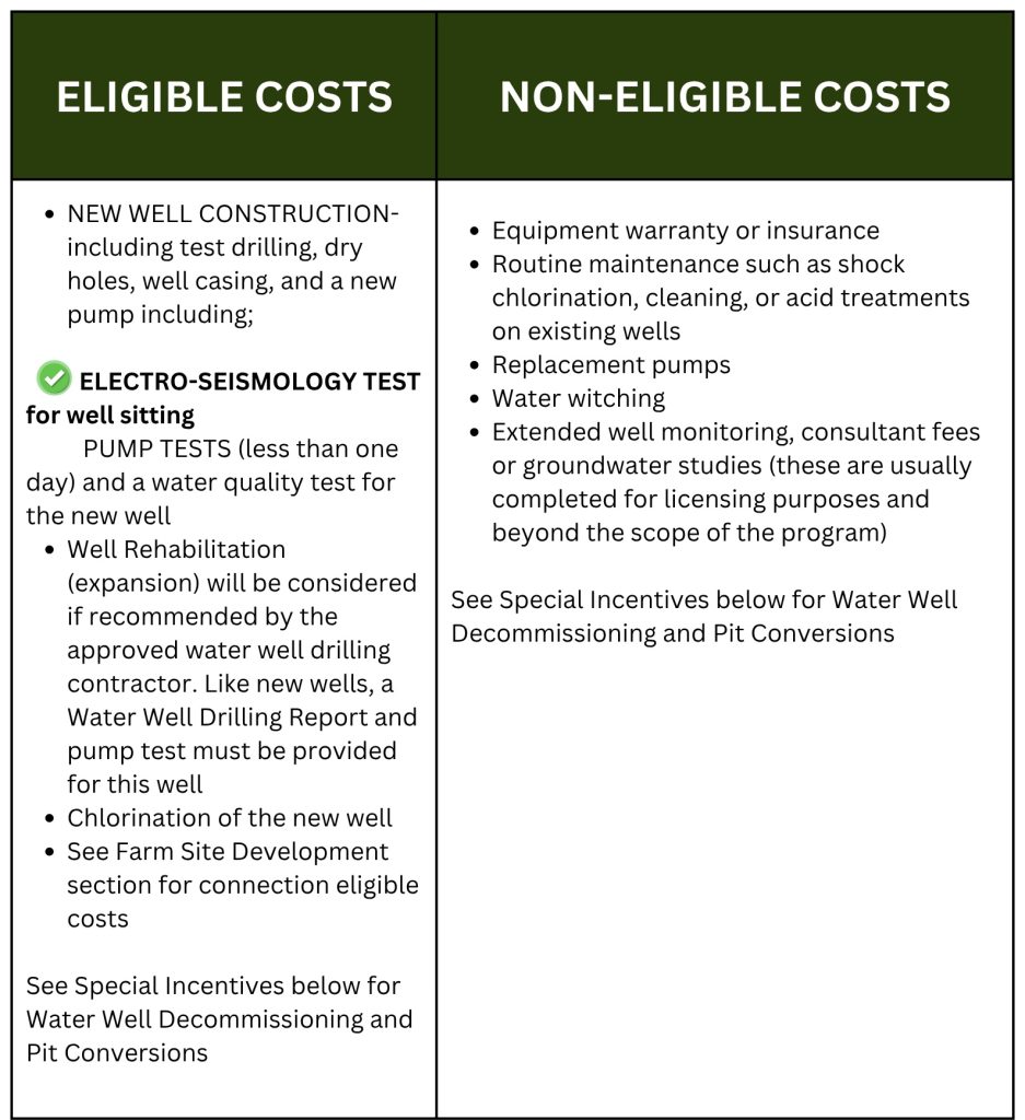
Funding and Grants for Farmers Drilling Wells
Farmers and agricultural property owners in Alberta may qualify for water management funding programs that assist with groundwater development and well drilling costs.
Some programs may help cover:
- Water well drilling
- Groundwater investigations
- Agricultural water supply improvements
- Water management projects
Funding and grant information for farmers drilling wells can be found here: http://www.growingforward.alberta.ca/Programs/index.htm?contentId=ONFARM_WTRMGT_PRG&useSecondary=true&active=yes
In some situations, approved groundwater investigation services may also qualify for funding support.
Tips for Researching Groundwater Information
When reviewing Alberta groundwater data, it is recommended to:
- Compare multiple nearby wells
- Review water yield and depth information carefully
- Examine geological formations encountered during drilling
- Use GPS coordinates whenever possible
- Consult qualified groundwater professionals before drilling
Groundwater conditions can vary significantly, even between neighboring properties, so existing records should be used as guidance rather than guarantees.
Canadian Well Records by Province
British Columbia Water Well Records
The British Columbia Ministry of Environment maintains an online groundwater well and aquifer database that allows users to search for water well information throughout the province. As a result, property owners, farmers, drilling contractors, and developers can quickly access important groundwater data before starting a drilling project.
British Columbia Water Well Database: http://maps.gov.bc.ca/ess/hm/wrbc/
In addition, the Ministry provides the eWELLS application for entering new well records into the database. Therefore, well information can continue to be updated and expanded across the province.
eWELLS Application– Users can search for groundwater records using:
- PID number
- Land description
- Well tag number
- Property information
British Columbia Well Search: https://a100.gov.bc.ca/pub/wells/public/indexreports.jsp
Furthermore, additional groundwater and aquifer information is available through FrontCounter BC.
FrontCounter BC: http://www.frontcounterbc.gov.bc.ca/ Phone: 877-855-3222
Setback Requirements in British Columbia– Before drilling a new well, property owners should also review setback requirements related to buildings, septic systems, and contamination sources. Consequently, understanding these regulations may help protect groundwater quality and avoid future issues.
For setback requirements in British Columbia, visit: http://www.env.gov.bc.ca/wsd/plan_protect_sustain/groundwater/library/faq_grdwater.html
New Brunswick Water Well Records
New Brunswick also provides online access to groundwater well information through its provincial database. Therefore, users can review local groundwater data before developing a new water source.
New Brunswick Water Well Database
http://app.elg-egl.gnb.ca/0375-0001/
Setback Requirements in New Brunswick
In addition, property owners should review setback regulations for buildings and septic systems before drilling.
Manitoba Water Well Records
At this time, Manitoba does not currently maintain a public online water well database. However, local government offices may still provide limited groundwater information upon request.
Newfoundland and Labrador Water Well Records
Groundwater and water resource mapping information is available through the provincial mapping system. Consequently, users can review regional groundwater resources and aquifer information online.
Newfoundland and Labrador Water Maps
Groundwater Information
http://www.env.gov.nl.ca/env/waterres/cycle/groundwater/index.html
Nova Scotia Water Well Records
Nova Scotia provides public access to well logs and groundwater information online. As a result, landowners can review nearby well data before drilling a new well.
Nova Scotia Well Logs Database
https://www.novascotia.ca/nse/welldatabase/wellsearch.asp
Saskatchewan Water Well Records
Saskatchewan provides groundwater and well management resources for landowners and rural property owners. Additionally, the province offers guidance related to groundwater protection and water well management.
Saskatchewan Setback Requirements and Well Management Guide
Ontario Water Well Records
Ontario maintains an online map and searchable database for water well records across the province. Therefore, property owners can research nearby wells and groundwater conditions more efficiently.
Ontario Water Well Records Map
http://www.ontario.ca/environment-and-energy/map-well-records
Yukon Water Well Records
Yukon groundwater and observation well information can be found through the Yukon Water database and federal aquifer mapping systems. In addition, users may contact Yukon Water Resources directly for specific well information.
Yukon Observation Wells: http://yukonwater.ca/monitoring-yukon-water/water-data-catalogue
National Groundwater Aquifer Map: http://ngwd-bdnes.cits.nrcan.gc.ca/service/api_ngwds:gin/en/wmc/aquifermap.html
For specific water well records, contact: Water.Resources@gov.yk.ca
Yukon Domestic Water Well Program (Financing): Yukon also offers information about domestic water well financing programs. http://www.community.gov.yk.ca/property/domesticwaterwell.html
Legal Land Description (LSD) Converter
Many provincial databases require legal land descriptions for accurate searches. Therefore, the following tool may help convert legal land descriptions and related property information more easily.
LSD Converter: http://www.legallandconverter.com/
Why Water Well Records Are Important
Water well records provide essential information about your groundwater source, well construction, and expected performance. Whether you’re buying a property, planning maintenance, or considering a new well, reviewing the well record can help you better understand the reliability and capacity of your water supply.
A properly documented water well record is an important tool for protecting your investment and ensuring long-term access to clean, dependable groundwater.
CONTACT US NOW!
+1 780 876 6676
3811-53 Ave Rocky Mountain House, Alberta T4T 1V4 Canada
Ready to find water with confidence?
Contact WaterFind Canada to request a customized groundwater survey estimate. We provide a simple DocuSign agreement and help property owners, farmers, ranchers, and businesses locate promising groundwater sources before drilling begins. Based in Rocky Mountain House, Alberta, we serve clients across Western Canada and beyond.