Modern Seismic Water Detection Technology
In the past, many people used dowsing or water witching to locate groundwater. Today, modern seismic water detection uses science-based methods to identify underground water-bearing zones before drilling begins. This technology works by sending controlled sound waves into the ground and analyzing how those waves respond to subsurface formations. As a result, property owners can make better decisions before investing in water well drilling.
How Seismic Aquifer Detection Works
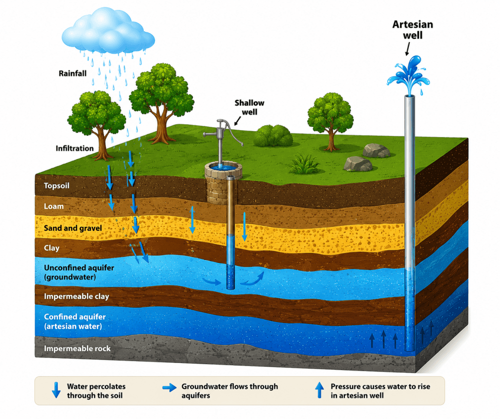
Seismic aquifer detection helps locate potential aquifers beneath a property. When seismic waves move through water-bearing formations, they create measurable signal changes below the surface. Surface antenna arrays detect these responses and separate them by travel time. This allows technicians to estimate aquifer depth, groundwater thickness, and subsurface structure with greater accuracy.
After the survey, analysts review the signal data to evaluate possible groundwater zones. The results can help estimate potential well yield in gallons per minute (GPM), depending on site conditions. Therefore, seismic water finding can reduce drilling uncertainty, lower the risk of dry wells, and support more accurate groundwater mapping.
Service Availability Across Canada
Seismic water finding services are useful for homeowners, farmers, ranchers, acreage owners, and commercial property owners planning a new water well. These surveys should be completed early in the planning stage. That way, property owners can understand aquifer depth, possible water yield, and stronger drilling targets before drilling starts. Field teams can serve many locations across Canada, with regular coverage in Western regions.
Site Requirements for Seismic Surveying
Ground Conditions
Seismic sounding requires undisturbed native soil for the most accurate results. If the site has already been excavated, filled, or leveled, crews may need to dig deeper to reach native soil. In addition, the upper 3 feet of the test area should contain less than 30% large gravel or cobbles. This helps improve signal quality during the groundwater survey.
Access and Setup Requirements
Each survey location must be accessible by pickup truck. The site should also provide a cleared working area of about 16 feet by 8 feet. If access is limited, extra charges may apply. In addition, the customer or an authorized representative should be present during the survey to help confirm the exact testing location.
Safety and Utility Clearance
All proposed sounding locations should be at least 50 feet away from electrical power sources. This is especially important near underground utilities. Therefore, clients must clearly mark buried lines, pipes, cables, and other infrastructure before testing begins. Proper utility clearance helps protect the crew, the equipment, and the property.
Survey Execution Details
Technicians usually conduct soundings every 100 feet in a straight line to build a clearer aquifer profile. This spacing helps create a more complete view of underground water-bearing formations. Finally, clients should confirm access, ground conditions, utility locations, and site preparation before booking. This helps ensure a smooth and successful seismic groundwater survey.
Frequently Ask Questions
How does seismic technology locate groundwater?
Seismic technology uses controlled sound waves to analyze subsurface formations. These waves interact with underground rock layers and aquifers, allowing specialists to identify potential groundwater zones, estimate aquifer depth, and evaluate water-bearing formations before drilling.
Can seismic surveys determine how much water an aquifer contains?
Seismic surveys can estimate aquifer thickness, depth, and potential water production. While actual well yields vary depending on local conditions, the data help improve drilling accuracy and reduce uncertainty before a water well is constructed.
Is seismic water detection more accurate than traditional water dowsing?
Yes. Modern seismic methods rely on measurable geological and geophysical data rather than intuition or divining rods. This scientific approach provides more reliable information about subsurface conditions and potential groundwater resources.
Why should I conduct a seismic survey before drilling a water well?
A seismic survey helps identify promising groundwater zones before drilling begins. This reduces the risk of drilling dry holes, improves well placement decisions, and can lower overall project costs.
What site conditions are required for a groundwater survey?
The survey area should have access to native soil, sufficient working space for equipment, and clear access for field vehicles. Property owners should also identify and mark underground utilities before testing begins.
How far from utilities should testing be performed?
Survey locations should remain at least 50 feet away from power sources and underground utilities. Maintaining proper clearance helps ensure safety and improves data quality.
Can seismic surveys be performed anywhere in Canada?
Field teams can conduct surveys throughout many regions of Canada, including rural, agricultural, residential, and commercial properties. Service availability may vary depending on location and accessibility.
How does seismic mapping help reduce drilling costs?
By identifying likely aquifer locations and estimating groundwater depth before drilling, seismic mapping helps contractors focus on the most promising targets. This can reduce unnecessary drilling and improve project efficiency.
Can seismic surveys help identify deep groundwater sources?
Yes. Modern seismic methods can detect subsurface formations at significant depths, helping specialists locate deeper groundwater zones that may not be visible through surface observations alone.
Is seismic groundwater detection environmentally friendly?
Yes. Seismic surveys are non-invasive and require minimal disturbance to the surrounding environment. They help support responsible groundwater development by improving drilling accuracy and reducing unnecessary exploration.
CONTACT US NOW!
+1 780 876 6676
3811-53 Ave Rocky Mountain House, Alberta T4T 1V4 Canada
Ready to find water with confidence?
Contact WaterFind Canada to request a customized groundwater survey estimate. We provide a simple DocuSign agreement and help property owners, farmers, ranchers, and businesses locate promising groundwater sources before drilling begins. Based in Rocky Mountain House, Alberta, we serve clients across Western Canada and beyond.